
The best GPS for kayaking should be rugged, water resistant, easy to read, accurate, and simple to use.
Picture yourself on a long Saturday paddle in the United States. You launch before sunrise, follow a quiet river, and soon lose sight of the launch point. Your phone has a weak signal, the glare makes the screen hard to read, and the battery is falling fast. This is where a dedicated GPS can help. A good kayak GPS can track your route, mark key spots, and help you find your way back. I look for simple controls, strong battery life, useful maps, and a tough build. In this guide, I compare six handheld GPS options for paddlers.
🏆 Top 3 Products

Garmin eTrex SE
Its compact handheld design and modern navigation features make it a strong fit for everyday paddling.

Garmin eTrex 22x
It offers a proven rugged form, color display, and mapping support for paddlers who want a simple outdoor navigator.

Garmin eTrex 10
Its simple interface and basic GPS navigation make it a practical choice for paddlers who need core location tools.
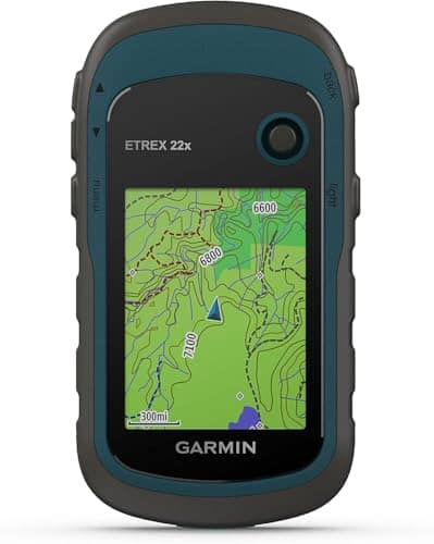
Garmin eTrex 22x: Rugged Kayak GPS
The Garmin eTrex 22x is a compact handheld GPS built for outdoor use. Its rugged shape makes it easy to carry on a kayak trip, hike, or camping day. I like the color display because it makes map details easier to follow than a basic monochrome screen. For paddlers who want a dedicated GPS without a large device, this model is a practical option.
The eTrex 22x also supports satellite navigation and mapping functions that can help with route planning and position checks. Its physical buttons are useful when your hands are wet or when you do not want to rely on a touch screen. It is a good match for lake trips, calm rivers, and other trips where a small handheld navigator can add peace of mind. I would still plan every trip with current charts, local rules, and weather information.
✅ Pros
- ✔ Rugged handheld design suits outdoor use.
- ✔ Color screen makes map details easier to view.
- ✔ Physical buttons work well with wet hands.
- ✔ Compact size is easy to carry in a kayak.
- ✔ Supports dedicated GPS navigation without using a phone.
- ✔ Useful for marking waypoints and checking position.
- ✔ A good fit for paddlers who want traditional handheld controls.
⚠️ Cons
- ✖ The smaller screen is not ideal for viewing large areas of map at once.
- ✖ It does not provide the smartphone-style interface some users prefer.
- ✖ Map and feature needs should be checked before buying for a specific waterway.
My Recommendation
I recommend the eTrex 22x to paddlers who want a classic handheld GPS with a color screen and a tough design. It is especially useful when I want physical controls and a dedicated navigation device instead of depending on my phone. For day trips on lakes and rivers, it offers a sensible balance of size, mapping, and outdoor durability.
| Best For | Why |
|---|---|
| Lake Kayaking | The compact color display and handheld design work well for checking position during lake trips. |
| River Paddling | Physical controls make it practical when hands are wet and conditions change. |
| Outdoor Navigation | It provides dedicated GPS navigation in a rugged handheld form. |
Handheld GPS Navigator: Rugged Kayak Option

This handheld GPS is designed for outdoor navigation and uses a 3.2-inch screen that is intended to remain readable in bright conditions. The larger screen can be useful when I want to see more information without holding the unit very close. Its rugged and waterproof design also fits the needs of paddlers who expect splashes and changing weather. The product is positioned as a navigation tool for hiking and other outdoor activities as well as kayaking.
Another useful feature is multi-GNSS support, which can help the device work with more than one satellite navigation system. The unit also comes with USA topographic map support and is designed with extended battery use in mind. These features can make it appealing for paddlers who travel beyond familiar local waters. Before a long trip, I would still test the unit, confirm the map coverage, and carry a backup navigation method.
✅ Pros
- ✔ 3.2-inch screen provides a useful viewing area.
- ✔ Designed for bright outdoor conditions.
- ✔ Rugged form suits outdoor adventures.
- ✔ Waterproof design fits splash-heavy activities.
- ✔ Multi-GNSS support adds satellite system flexibility.
- ✔ USA topographic map support is useful for land and water planning.
- ✔ Extra battery-life focus can help on longer outings.
⚠️ Cons
- ✖ It may have a less familiar interface than established Garmin handheld units.
- ✖ Users should confirm map details and coverage for their exact paddling area.
- ✖ A larger handheld body can take more space than a small GPS unit.
My Recommendation
I would consider this model for paddlers who want a larger screen and a broad set of outdoor navigation features. It can suit users who also hike, camp, or explore remote areas. The waterproof build, multi-GNSS support, and USA map focus make it worth considering when I need one device for several outdoor uses.
| Best For | Why |
|---|---|
| Multi-Sport Users | Its outdoor navigation design can serve both kayaking and land-based trips. |
| Bright-Day Paddling | The 3.2-inch screen is designed for outdoor viewing. |
| Long Outdoor Trips | The product emphasizes extended battery use and multi-GNSS support. |
Garmin Drive 53: Car GPS For Kayak Trips

The Garmin Drive 53 is different from the other devices in this guide because it is designed primarily for vehicle navigation. That distinction matters for kayaking. I would use this device to get to a launch site, campground, marina, or parking area rather than as my main on-water GPS. Its large navigation display can be helpful during the road part of a paddling trip.
For a kayak outing, the Drive 53 is best viewed as a companion device. It can help with the drive to the water, but it is not the same type of rugged handheld navigator as the eTrex models. If I need a dedicated GPS that can travel with me on the kayak, I would look at the handheld options in this list first. Still, road navigation can be an important part of a kayaking trip, especially when I visit unfamiliar launch points.
✅ Pros
- ✔ Designed for road navigation.
- ✔ Useful for reaching unfamiliar kayak launch sites.
- ✔ Large display can make driving directions easier to follow.
- ✔ Dedicated navigation reduces phone dependence during the drive.
- ✔ Useful as a trip-planning companion for paddlers.
- ✔ Can help with road routes before reaching the water.
- ✔ Simple purpose makes it easy to understand for vehicle travel.
⚠️ Cons
- ✖ It is not a dedicated handheld kayaking GPS.
- ✖ Its vehicle-focused design is less suitable for on-water navigation.
- ✖ It should not be treated as a replacement for marine charts or a suitable handheld GPS.
My Recommendation
I recommend the Drive 53 only for the road portion of a kayak adventure. It can be useful when I drive to new lakes, rivers, or launch areas, but I would choose a handheld outdoor GPS for navigation on the water. This distinction is important when shopping for the best gps for kayaking because a car GPS and an outdoor handheld GPS solve different problems.
| Best For | Why |
|---|---|
| Road Trips | It is designed for vehicle navigation before and after the paddle. |
| Remote Launch Sites | A dedicated car navigator can help when driving to unfamiliar access points. |
| GPS Companion | It can complement a handheld outdoor GPS during a full kayaking trip. |
Garmin Oregon 550T: Classic Outdoor GPS

The Garmin Oregon 550T is a classic outdoor handheld GPS with a 3-inch class touch display and a built-in digital camera. It was designed around outdoor navigation, so its form makes more sense for kayaking than a standard car GPS. The touchscreen approach gives it a different feel from button-driven eTrex units. For users who enjoy older Garmin outdoor hardware, this model can still be an interesting option.
Its topographic mapping focus can help users plan routes across land and outdoor areas. The camera is an extra feature that may appeal to travelers who like to record locations and moments without reaching for a phone. However, this is an older model, so I would pay close attention to condition, battery health, map availability, and seller details. Those checks matter more when buying legacy GPS hardware.
✅ Pros
- ✔ Outdoor-focused handheld design.
- ✔ Touchscreen interface offers simple map interaction.
- ✔ Topographic mapping supports outdoor route planning.
- ✔ Built-in camera adds a useful travel feature.
- ✔ Compact enough for carrying during a paddle.
- ✔ Can be useful for users who prefer traditional Garmin outdoor devices.
- ✔ Dedicated GPS navigation reduces reliance on a phone.
⚠️ Cons
- ✖ It is an older GPS model.
- ✖ Battery condition can vary when buying used or older stock.
- ✖ Map compatibility and update options should be checked before purchase.
My Recommendation
I would consider the Oregon 550T mainly if I find a unit in good condition and want an older Garmin outdoor GPS. Its topographic mapping and handheld format fit outdoor use, but buyers should understand that newer devices may offer a more current experience. For me, the main buying check would be the condition of the actual unit and the maps available for the places I plan to paddle.
| Best For | Why |
|---|---|
| Classic GPS Fans | The Oregon series has a familiar outdoor handheld design. |
| Topographic Mapping | Its design centers on outdoor mapping and navigation. |
| Budget Shoppers | Older hardware may be appealing when available at a suitable price. |
Garmin eTrex 10: Simple Handheld GPS
The Garmin eTrex 10 focuses on basic handheld GPS navigation. It uses a simple interface and monochrome display instead of trying to provide a large set of advanced visual features. I see that simplicity as useful for paddlers who mainly need to know where they are, mark locations, and follow a basic route. It also keeps the device small and easy to carry.
The eTrex 10 can make sense for beginners who do not want a complex GPS. Its worldwide positioning focus also makes it useful beyond a single region. The trade-off is that the display and mapping experience are more basic than what I get from a color-screen model. For simple navigation, though, that can be a reasonable trade.
✅ Pros
- ✔ Simple interface is friendly for beginners.
- ✔ Compact design is easy to carry.
- ✔ Physical controls are useful with wet hands.
- ✔ Worldwide navigation support is practical for travel.
- ✔ Dedicated GPS reduces phone battery use.
- ✔ Basic design can be easier to learn than a feature-heavy device.
- ✔ Suitable for paddlers who want core navigation functions.
⚠️ Cons
- ✖ The monochrome display is less visual than a color mapping screen.
- ✖ Mapping detail is more limited than on more advanced handheld models.
- ✖ Users who want rich maps may prefer a newer color-screen GPS.
My Recommendation
I recommend the eTrex 10 for paddlers who value simple navigation over a large map display. It is a good starting point if I want a dedicated GPS and do not need advanced map visuals. I would choose it for basic trips, route tracking, and waypoint use rather than complex navigation in unfamiliar waterways.
| Best For | Why |
|---|---|
| Beginners | The simple interface is easier to learn than many advanced GPS systems. |
| Basic Route Tracking | It provides core location and route functions without extra complexity. |
| Lightweight Carry | The compact handheld form is easy to bring on a kayak. |
Garmin eTrex SE: Modern Handheld GPS
The Garmin eTrex SE brings the familiar eTrex handheld idea into a newer model. It is small enough to carry on a kayak yet built for outdoor navigation rather than car travel. I like this style of GPS because physical controls can be easier to use when the paddle deck is wet. The compact size also makes it simple to store in a dry bag or accessible gear pocket.
For paddlers, a device like the eTrex SE can provide a dedicated navigation option without turning a phone into the main safety tool. It can be useful for recording routes, checking position, and marking locations during outdoor trips. As with any GPS, I would use it as one part of a navigation plan rather than my only safety resource. I would also test battery life and settings before a long trip.
✅ Pros
- ✔ Compact handheld form fits kayak gear well.
- ✔ Outdoor-focused design suits paddling and hiking.
- ✔ Physical controls can work well with wet hands.
- ✔ Dedicated GPS reduces reliance on a smartphone.
- ✔ Useful for route tracking and waypoint work.
- ✔ Modern eTrex design is easy to carry.
- ✔ Can serve multiple outdoor activities beyond kayaking.
⚠️ Cons
- ✖ The compact screen cannot show as much map detail as a large navigator.
- ✖ Users who prefer full touchscreen controls may need time to adjust.
- ✖ Map and connectivity features should be checked against personal trip needs.
My Recommendation
The eTrex SE is a strong match for paddlers who want a modern handheld GPS in a small package. I would choose it when portability, dedicated navigation, and simple outdoor use matter more than having a large screen. It also works well for people who hike and camp, since the same type of GPS can support several outdoor activities.
| Best For | Why |
|---|---|
| Everyday Kayakers | Its compact outdoor design is easy to carry on regular paddling trips. |
| Hiking and Kayaking | The handheld format can serve both water and land adventures. |
| Minimalist Gear | It provides dedicated GPS navigation without requiring a large device. |
Final Verdict: Which Should You Buy?
For my overall kayaking use, I would choose the Garmin eTrex SE when I want a compact and modern handheld GPS. The Garmin eTrex 22x is another strong option when I want a color display and a proven outdoor design. The eTrex 10 keeps things simple for basic navigation, while the larger rugged handheld in this list may suit users who want a 3.2-inch screen and multi-GNSS support. The Garmin Drive 53 belongs mainly in the vehicle part of the trip, and the Oregon 550T is an older option that needs careful condition and map checks.
Choosing the best gps for kayaking comes down to the water you paddle, the maps you need, and how much detail you want on screen. I would test any GPS before a major trip, carry a backup navigation method, and check weather and local water conditions. With the right handheld GPS, kayak navigation can feel simpler, safer, and more organized.
FAQs Of best gps for kayaking
Q What should I look for in the best gps for kayaking?
Q Can I use my phone instead of a kayak GPS?
Q Is a waterproof GPS important for kayaking?
Q Do I need maps on my kayaking GPS?
Q What is the best gps for kayaking on rivers and lakes?